Australian Towns & Cities
Victoria: Melbourne CBD
Incorporating photos and Information
from Michael Greenslade's former Australian Towns, Cities and Highways
site
Melbourne is the country’s second largest city and the capital of Victoria. The city itself sits on the northern banks of the Yarra River, about five kilometres from Port Phillip Bay. Melbourne’s suburbs extend around Port Phillip Bay, into the plains to the west and east and out to the foothills of the Dandenongs.
Founded in 1835 on the banks of the Yarra River just north of the tip of Port Phillip Bay, the city grew quickly as a port due to the close proximity of the gold fields to the north and west. Many of Melbourne's wide, tree lined streets were laid out during the wealthy gold rush times, resulting in a high amount of mansions and terrace housing that still dominates the CBD area today. Melbourne's CBD is easy to reach and simple to navigate due to the grid street layout and relatively flat terrain. The streets in the city centre are wide, and cater greatly for the unique large fleet of trams that service the CBD and surrounding suburbs. In addition, the city is riddled with many tall and elegant buildings, a seemingly endless shopping & commercial precinct and several large parks (including the Royal Botanic Gardens) that almost surround the city centre.
Other highlights include the Eureka 88 Skydeck, Rialto Towers (which featured Melbourne's first skyscraper public observation deck, that operated between 1994 and 31 December 2009), Flinders St Station, the Victorian Arts Centre, the Crown Casino and the Queen Victoria Markets. To the south, just over the Yarra River lies the popular precinct of Southbank. The walk from Princes Bridge west to Spencer St Bridge offers great shopping, dining with several interesting fountains, sculptures and cafes - cruises along the Yarra River can also be embarked upon from Southbank. Also within the vicinity of the CBD are Docklands Stadium (1km west), Melbourne Cricket Ground (2km east), Albert Park (Grand Prix - 3km south) and the National Tennis Centre/Olympic Park (2km east). Certainly a great place to visit and explore - the city is also a good base to explore the wonderful Dandenong Ranges to the east, Phillip Island & Mornington Peninsula to the south and the goldfields region to the west & north-west.
- Population: 4 485 211 1
- Postcode: 3000
- Location: Capital city of Victoria, 870 km southwest of Sydney, 730 km southeast of Adelaide
- Main Roads: Monash, Princes, Westgate Freeways and Citylink M1, Tullamarine Freeway M2, Eastern Freeway / Eastlink M3, Western Freeway M8, Hume Freeway M31, Calder Freeway M79, Western Ring Road / Metropolitan Ring Road M80
- Radio Stations: DAB+: 1116 SEN, 3CR, 3KND, 3MBS, 3RRR, 3ZZZ, Buddha Hits, Chemist Warehouse Remix, Coles Radio, EASY Hits, Fox FM Gold '00s, Gold 104.3, Gold '80s, Gold '90s, IRIS, Joy, KIIS 101.1, Kinderling Kids, Light 899, Light Digital, Macquarie Sports Radio 1278, News Talk Sport (NTS), Nova 100, Oldskool Hits, PBS Digital, RSN Carnival, RSN Carnival 2, RSN Racing & Sport, Rythmos, SEN+, SEN2, SEN3, smooth 91.5, smooth Chill, smooth Relax, SYN, TAB Live, The Edge Digital, Triple M, Triple M Aussie, Triple M Classic Rock, Triple M Country, Triple M Greatest Hits, Urban Hits and VAR digital. FM: 3MBS (103.5 MHz), 3MDR Mountain Districts Radio (97.1 MHz), 3NRG (99.3 MHz), 3RPP (98.3 MHz / 98.7 MHz), 3RRR (102.7 MHz), 3WBC (94.1 MHz), 3ZZZ (92.3 MHz), 96.5 Inner FM (96.5 MHz), 979fm – Melton (97.9 MHz), ABC Classic (105.9 MHz), Apple FM (98.5 MHz), Arabic Language Radio (Reservoir) (87.6 MHz), Casey Radio (97.7 MHz), DCFM 88 (88.0 MHz), Eastern FM (98.1 MHz), Fox Hit 101.9 (101.9 MHz), Gold 104.3 (104.3 MHz), Golden Days Radio (95.7 MHz), Highlands FM (100.7 MHz), Hillside Radio (Bayswater) (87.6 MHz), J-Air (87.8 MHz), JOY 94.9 (94.9 MHz), KIIS 101.1 (101.1 MHz), Kiss FM (Melbourne CBD, Frankston & Mornington Peninsula) (87.6 / 87.8 / 87.9 MHz), Light FM (89.9 MHz), North West FM (98.9 MHz), Nova 100 (100.3 MHz), PBS FM (106.7 MHz), Plenty Valley FM (88.6 MHz), SBS Radio (93.1 MHz), smoothfm 91.5 (91.5 MHz), Southern FM (88.3 MHz), Stereo 974 Western Suburbs Community radio (97.4 MHz), Surf FM (Frankston & Cranbourne) (87.6 MHz), SYN 90.7 (90.7 MHz), Triple J (107.5 MHz), Triple M (105.1 MHz), Wyn FM (88.9 MHz) and Yarra Valley FM (99.1 MHz). AM: 2ME Radio Arabic (1638 kHz), 3AW (693 kHz), 3CR (855 kHz), 3CW (1620 kHz), 3CW (1629 kHz), 3KND (1503 kHz), 3MP – SEN+ (1377 kHz), 3RPH (1179 kHz), 3XY Radio Hellas (1422 kHz), ABC NEWS (1026 kHz), ABC Radio Melbourne (774 kHz), ABC Radio National (621 kHz), Islamic Voice Radio (1701 kHz), Lion 1674 (1674 kHz), Macquarie Sports Radio (1278 kHz), Radio Haanji (1674 kHz), Rete Italia (1593 kHz), RSN (927 kHz), Rythmos 1656 (1656 kHz), SBS Radio 1 (1224 kHz), SEN 1116 (1116 kHz) and Vision Christian Radio (1611 kHz / 1665 kHz),
View Larger Map
 |
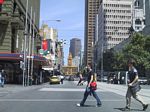
Melbourne CBD:
Corner of Elizabeth and Collins Streets in Melbourne, with Flinders St station in the distance, 2003.
Image © Jamie Scuglia
|
 |
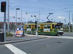
Melbourne Tram:
Ubiquitous A1-Class Tram outside Melbourne Park on Batman Av, 2003.
Image © Jamie Scuglia
|
1 Australian Bureau of Statistics, 2016 Census QuickStats
Last updated: 02-Dec-2019 1:01
This site ©
Paul
Rands. All rights reserved. Some portions © (copyright) by their
respective and credited owners. Permission must be obtained before using
any images from this site. For details, please email by clicking
here.