Australian Towns & Cities
Queensland: Chinchilla
Incorporating photos and Information
from Michael Greenslade's former Australian Towns, Cities and Highways
site
Chinchilla is a pleasant town, located on the Warrego
Highway and set adjacent to Charley's Creek. The town was settled in the
mid 1890's, its name originating from the Aboriginal word "jinchilla"
meaning cypress pine (large quantities of the species in the area) and is
the centre for the region's cattle and grain industries. The town is quite
attractive - the wide, shady main street set away from the highway is
excellent as is the expansive railway park.
- Population: 5877 1
- Postcode: 4413
- Location: 292 km west of
Brisbane
- Main Roads: Warrego Hwy (A2)
- Radio Stations: FM:
Hit 89.1 (89.1 MHz), Rebel FM (97.1 MHz), The Breeze (95.5
MHz), Three Angels Broadcasting Network (88.0 MHz) and Vision Christian
Radio (87.6 MHz). AM: 4SB (1071
KHz)
View
Larger Map

|
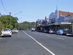
Chinchilla Town Centre:
View of Chinchilla town centre along Chinchilla St (Warrego Hwy),
April 2004.
Image © Michael Greenslade
|

|
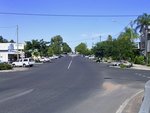
Chinchilla Town Centre:
View of Chinchilla town centre looking south along Heeney St, April
2004.
Image © Michael Greenslade
|

|
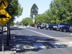
Chinchilla Town Centre:
View of Chinchilla town centre along Heeney St, between Bell and
Middle Streets, April 2004.
Image © Michael Greenslade
|
1
Australian Bureau of Statistics, 2016 Census QuickStats
Last updated: 18 Nov 2019 14:01
This site ©
Paul
Rands. All rights reserved. Some portions © (copyright) by their
respective and credited owners. Permission must be obtained before using
any images from this site. For details, please email by clicking
here.