Road
Photos & Information: Victoria
 |
|
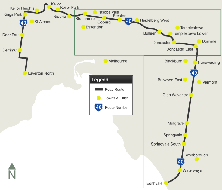
Fitzgerald Road, Boundary Road, Mount Derrimut Road, Station Road, Taylors Road, Green Gully Road, Calder Freeway, Tullamarine Freeway, Bell Street, Banksia Street, Manningham Road, Williamsons Road, Doncaster Road, Mitcham Road, Springvale Road and Edithvale Road (Metropolitan Route 40) |
Statistics:
- Length: 83 km
- Western
Terminus: Princes Freeway (M1) and Kororoit Creek Road (MR35) at
Laverton North
- Eastern
Terminus: Nepean Highway (MR3) at Edithvale
- Suburbs, Towns
& Localities Along The Route: Laverton North, Derrimut, Deer
Park, Cairnlea, St Albans, Kings Park, Delahey, Keilor Downs, Kealba,
Keilor, Keilor Park, Keilor East, Niddrie, Airport West, Essendon
Fields, Essendon North, Strathmore, Pascoe Vale, Pascoe Vale South,
Coburg, Preston, Heidelberg West, Heidelberg Heights, Heidelberg,
Bulleen, Templestowe Lower, Doncaster, Doncaster East, Donvale,
Nunawading, Forest Hill, Burwood East, Glen Waverley, Mulgrave,
Springvale, Springvale South, Keysborough, Braeside, Waterways,
Aspendale Gardens, Chelsea Heights and Edithvale
Route Numbering:
- Current:

- Former:
 1
1
- Multiplexes:


 M79 2
M79 2
- Road Authority
Internal Classification: 1530 (Calder Fwy), 1810
(Tullamarine Fwy), 5221 (Manningham Rd), 5225
(Williamsons Rd), 5137 (Fitzgerald Rd), 5797 / 5929
(Springvale Rd), 5804 (Mitcham Rd), 5805 (Doncaster Rd), 5875 (Keilor-Laverton Rd), 6400 (Bell St and Springvale Rd) 3
General Information:
Metropolitan Route 40 is a major arterial route
that cuts through several Melbourne suburbs. It's a multi-laned route
for the most part and has undergone several route changes over the
years, which are explained in the history section below.
Multiplexes along the route include:
- Tourist Drive 2, Banksia St, for 1 km from Heildelberg to Bulleen
- Metropolitan Route 36, for 5 km along Doncaster Rd, Doncaster to
Mitcham Rd, Donvale.
- Metropolitan Route 43, Tullamarine Fwy, for 3 km from Niddrie to
Strathmore
- Metropolitan Route 47, Williamsons Rd, for 900 m at Doncaster
- M79, Calder Fwy, for 6 km from Keilor to Niddrie
In 1997, plans were made to realign MR40
along the Eastern Fwy (newly extended at the time), but part way
through the resignage process, this was halted. Click here for more information, at the Main Road Victoria site, maintained by Viseth Uch.
History:
- 1866: A tollhouse was built and was situated at the intersection
of
Doncaster Road and Williamsons Road, Doncaster,. When tolls
were abolished it was moved to a position behind Lauer's store at the
corner of Doncaster Road and Elgar Road. 4
- 1970: Construction of Tullamarine Fwy 5, replacing Lancefield Road past Essendon Airport. 6
- 1970s: MR40 duplexed along the Tullamarine Freeway.
MR40 as a result, was removed from Reynard Street, Pascoe Vale Road,
Bulla Road and Lancefield Road. 1
- 1972: Tullamarine Fwy connection to the then newly built Calder Fwy constructed. 6
- 1979: Tullamarine Fwy between Essendon Airport and Calder Fwy upgraded to freeway standards. 6
- 1989: A review of routes in Victoria, saw MR40
extended west of Reynolds Parade at Pascoe Vale South to the current
terminus in Laverton North. The route was also moved from Huntingdale
Road (now MR47) and extended along Springvale Road (formerly MR11). 1
- December 1997: Opening of the Eastern Fwy (M3) interchange with Springvale Rd in Donvale. 7
- October
2006: Opening of additional traffic lanes, inbound, on Tullamarine Fwy
at Niddrie and Essendon North, near the interchange with the Calder Fwy. 8
- February 2007: Opening of additional traffic lanes, outbound, on
Tullamarine Fwy at Niddrie and Essendon North, near the interchange
with the Calder Fwy. 8
- 4
February 2009: Works to the Eastern Fwy interchange, on Springvale Rd
at Donvale. These
included widening of the bridge, reconfiguration of the lanes and
upgrades to
the traffic signals as part of the
final interchange configuration for EastLink. 9
- 23
September 2009: The main section of the Springvale Road railway
overpass at Nunawading completed, followed by on-going construction
work to complete the entire project. 10

1 Tim Cole
2 Melway Street Directory, Edition 37
3 VicRoads Road Management Plan, 30 October 2004
4 Picture Australia, 1958 Doncaster Tollhouse
5 Parliament of Victoria, A Story In Time, Children of the Revolution - 1970-1979
6 Viseth Uch
7 Department of Premier & Cabinet, Media Release, Clean Bill of Health for Air Quality Report, 2 March 2008
8 Building of Victoria Magazine, Issue 6, Freeway upgrade almost complete
9 Linking Melbourne Authority, Latest News, 30 January 2008
10 Victorian Department of Transport, eNews, October 2009
Last updated: 02-Jun-2017 23:47
This site © Paul Rands. All rights reserved. Some portions © (copyright) by their respective and credited owners. Permission must be obtained before using any images from this site. For details, please email by clicking here.


 1
1


 M79 2
M79 2