Road Photos & Information: Victoria: Ballarat-Buninyong Road (C294)
C294 Ballarat-Buninyong Road (C294)

Statistics:

Route Numbering:

General Information:

C294 is the former alignment of the Midland Highway, and is a route that runs parallel with the Midland Hwy (A300) between Ballarat and Buninyong, and acts as an alternate route between the 2 towns, and also services east Ballarat and the small towns between Ballarat and Buninyong.

History:
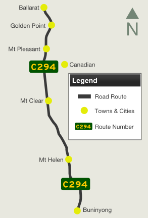
Buninyong to Ballarat Ballarat to Buninyong
Preview: Description: Preview: Description:
tn_200612_01_ballarat.jpg Advance Directional Sign:
AD sign missing route numbers on Main Road (C294) at East Ballarat approaching the northern terminus of C294, Barkly Street (C298), December 2006

Image © Rob Tilley

tn_200612_02_ballarat.jpg Intersection Directional Sign:
ID sign on the junction with Barkly St (C298) in East Ballarat, December 2006

Image © Rob Tilley

tn_200612_01_ballarat.jpg Distance Sign:
RD sign after the Barkly St intersection in Ballarat East, December 2006

Image © Rob Tilley

tn_200612_03_ballarat_bradshawst.jpg AD Sign:
Advance directional sign approaching Bradshaw and Lal Lal Street at Golden Point, December 2006

Image © Rob Tilley

1 Viseth Uch
2 VicRoads Road Management Plan, October 2004
3 City of Ballarat

Last updated: 12-Feb-2019 5:23

This site © Paul Rands. All rights reserved. Some portions © (copyright) by their respective and credited owners. Permission must be obtained before using any images from this site. For details, please email by clicking here.