|
|
|
|
|
 |
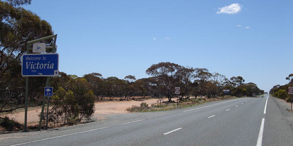
| Border welcome sign on the South Australia / Victoria border west of Ned's Corner, Victoria. Image © Paul Rands |
You've arrived at the road photos and information section that covers Victoria.
In Victoria, as is the case with all the other states in Australia, the roads are classified into different categories, and are also numbered for maintenance purposes and also navigation purposes.
Victoria covers an area of 227 416 square kilometres on the south-eastern part of Australia. 1 VicRoads manages and develops major arterial roads and freeways (excluding tollways) which form part of Victoria's road network, which comprises of approximately 22,300 km of roads and 5,250 bridges and major culverts. 2
For a full run down of Victoria's roads and the history of those that maintained them, click here.
According to the VicRoads web site, Roads in Victoria are divided into three types: 2
| Road Classification | Managed By |
| Freeways | VicRoads |
| Tollways | Melbourne CityLink is a privately operated tollway forming part of the overall inner Melbourne freeway system and is operated by Transurban |
| Ubran Arterial roads |
Operational
responsibility
Coordination
responsibility |
| Non-urban Arterial Roads | Usually local Council, but may be joint responsibility. |
| Municipal Roads (Local roads in towns, suburbs and throughout country Victoria) |
Local Governement (Councils) for municipal roads. |
| other minor roads and tracks in parks and forests | Department of Sustainability & Environment (DSE) including Parks Victoria for other minor roads and tracks in parks and forests. |
Route Numbering is designed to aid motorists navigate. In Victoria there is currently 2 systems in use. Alphanumeric numbering in the non-metropolitan areas and route shield numbering in Melbourne. Victoria is in the process of converting to the alphanumeric style of route marking, which began in 1996. The shield system is leftover from when Victoria used the system statewide, which started in 1965.
Outside of the metropolitan area, National Highways and National Routes have been converted to alphanumeric route numbers, however National Highways are still marked with the traditional National Highway shield (but with a lettered prefix, similar to other alphanumeric numbers), despite the National Highway system being replaced with the Federal Government's Auslink scheme.
Victoria's route numbering system currently consists of six types of numbering:
To check out the routes used in Victoria and photos of them, click on one of the section names below:
| M1 |  |
Decommissioned | |
| Alphanumeric Routes | National Routes | Metropolitan Routes | Decommissioned Routes |
| Alphanumeric routes are the newest form of route numbering in Victoria. Roads are numbered with M, A, B and C prefixes indicating the importance / standard of the route. | The black on white markers indicate highways around Australia which are not part of the National Highway System but are still of some national signifcance. | The white on blue shields indicate major urban routes. | Routes that were once numbered using the previous hierarchical route numbering scheme or routes that have had their number removed due to diminished importance. |
1 Geoscience Australia
2 VicRoads
Last updated: 31-Jan-2019 15:23
This site © Paul Rands. All rights reserved. Some portions © (copyright) by their respective and credited owners. Permission must be obtained before using any images from this site. For details, please email by clicking here.