Road Photos &
Information: Tasmania
| B32 |
|
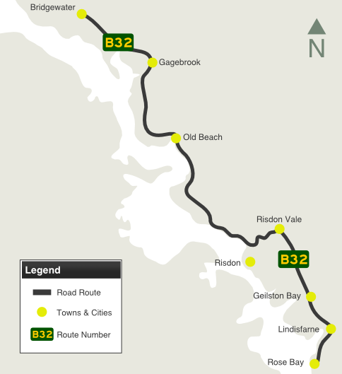
East Derwent Highway (B32) |
Statistics:
- Length: 22 km
- Northern Terminus: Midland Hwy (NH1) at
Bridgewater
- Southern Terminus: Tasman Hwy (A3) at Rose Bay
- Suburbs, Towns & Localities Along Route: Bridgewater,
Gagebrook, Old Beach, Risdon Vale, Geilston Bay, Lindisfarne and Rose
Bay
Route Numbering:
General Information:
B32 is an arterial route that parallels the eastern
banks of the Derwent River in Hobart. It is a mix of divided and undivided
road which passes through residential, commercial, and bushland areas.
History:
- 2011: A trial was conducted on a section covering over 100 metres of
the East Derwent Highway, from the Ronnie Street junction towards the
Tasman Bridge, where recycled crushed glass was used as a substitute for
sand in the asphalt mix. 1
- 4 April 2016: Opening of upgraded East Derwent Hwy / Tasman Hwy
interchange. 2
- 3 June 2016: Upgrade works including bus bay improvements on the East
Derwent Highway, landscaping and installation of barriers completed. The
shared pathway between the East Derwent Highway overpass and the Tasman
Highway overpass also officially opened to the public. 2

|
|
 |
Advance Directional
Sign:
AD sign at Gagebrook approaching Old Beach Rd, March 2016.
Image © Garry Coxhead
|
|
 |
Reassurance
Directional Sign:
Distance sign near Goodwood Rd at Risdon, 2008.
Image © Jamie Scuglia
|
|
|
|

|
Advance
Directional Sign:
AD sign approaching Midland Hwy (NH1) at Bridgewater, 2008.
Image © Jamie Scuglia
|
1 Local
Government Association Tasmania, LGAT News, September 2011
2 Department of State Growth,
Transport, Roads and Traffic, Road Projects, Tasman / East Derwent Highway
Interchange Improvements, Latest News, retreived 30 June 2016
Last updated: 17-Jul-2020 18:03
This
site ©
Paul Rands. All rights reserved. Some portions © (copyright) by their
respective and credited owners. Permission must be obtained before using
any images from this site. For details, please email by clicking
here.

