Road Photos & Information: South Australia

|
|
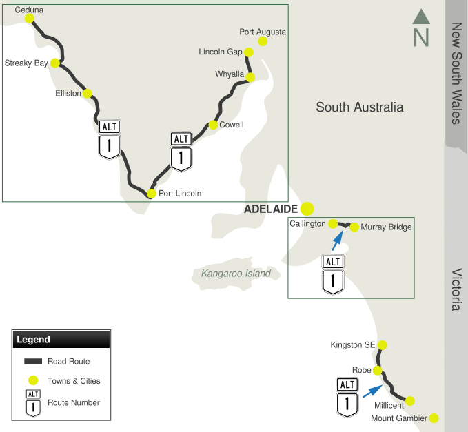
Lincoln Highway, Flinders Highway, Old Princes Highway, Callington Road & Southern Ports Highway (Alternate National Route 1) (Decommissioned) |
Statistics:
- Length:
- Lincoln Highway & Flinders Highway: 720 km
- Old Princes Highway: 33 km
- Southern Ports Highway: 121 km
- Terminii:
- Lincoln Highway & Flinders Highway: (Eastern: Eyre Highway (NH1), Lincoln Gap, 26 km west of Port Augusta. Western: Eyre Highway (NH1), Ceduna, 5 km east of the CBD)
- Old Princes Highway: (Eastern: Princes Hwy (NH1) & Old Princes Hwy, Murray Bridge. Western: Princes Hwy (South East Freeway) (NH1), Callington)
- Southern Ports Highway: (Northern: Princes Hwy (NR1) at Kingston SE. Southern: Princes Hwy (NR1) at Millicent)
- Suburbs, Towns & Localities Along Route:
- Lincoln Highway & Flinders Highway: Lincoln Gap, Whyalla, Cowell, Port Lincoln, Elliston, Streaky Bay and Ceduna
- Old Princes Highway: Murray Bridge, Monarto and Callington
- Southern Ports Highway: Kingston SE, Robe, Beachport and Millicent
Route Numbering:
- Current:

- Former:

General Information:
Alternate National Route 1 was a collection of separate roads in different parts of South Australia that paralleled National Route 1 or offered a different route to the same destinations, but in the case of Murray Bridge to Callington, the route is the former NR1 routing. The route of ALT-NR1 between Kingston SE and Millicent is the pre-1933 Princes Hwy routing. All of the ALT-NR1 routes in South Australia are rural highway standard, generally with 2 lanes in each direction, mostly servicing tourist areas and passing through mostly residential, rural and commercial zones.
History:
Old Princes Highway & Callington Road:
- 1938: Mount Barker Rd renamed Princes Hwy. 1
- 1950s: Duplication of highway between Glen Osmond and Crafers. 1
- 1955: The route from the Vic/SA Border to Tailem Bend was fully sealed, National Route 1 shield implemented. 1
Lincoln Highway & Flinders Highway:
- February 1978: An old road plough was placed beside the Flinders Highway to mark the sealing of the last stretch of highway between Talia and Streaky Bay, on Eyre Peninsula. The then Transport Minister, Mr Geoff Virgo, officially opened the Highway. 2
- 1998: ALT-NR1 switched to B100 in the change to alphanumeric route numbering, however many ALT-NR1 signs remain along the route. 1
Southern Ports Highway:
- 1933: Princes Highway moved to new alignment between Millicent and Kingston SE to the east of the existing highway. 1
- 1978: Introduction of ALT-NR1. 1
To view photos of section of the route, click inside the green boxes below:

1 Sam Laybutt (Ozroads)
2 History Trust of South Australia
Last updated: 27-Nov-2020 17:05
This site © Paul Rands. All rights reserved. Some portions © (copyright) by their respective and credited owners. Permission must be obtained before using any images from this site. For details, please email by clicking here.


