Road Photos & Information: South Australia
Statistics:
- Length: 266 km
- Western Terminus: Augusta Highway (A1) at Crystal Brook
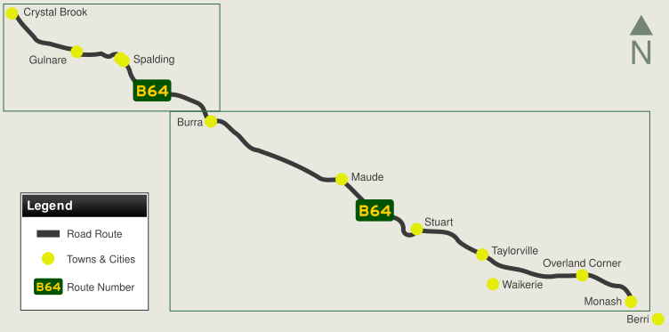
- Eastern Terminus: Sturt Hwy (A20) at Monash
- Roads the form the route: Old Princes Highway, Clare Highway, Main North Road, Gulnare-Spalding Road, New Road, Ford Road, Barrier Highway, Spalding-Burramble-Morgan Road, Morgan Terrace & Morgan-Renmark Road
- Suburbs, Towns & Localities along route: Crystal Brook, Narridy, Gulnare, Spalding, Burra, Maude, Morgan, Taylorville, Devlins Pound, Overland Corner and Monash
Route Numbering:
- Multiplexed With: A32 B80 B82
- Former:


- Road Authority Internal Classification: 03160 (Gulnare), 03400 (Burra to Mt Bryan), 03497 (Crystal Brook), 03498 (Gulare to Crystal Brook), 03583 (Spalding to Gulnare), 03692 (Mt Bryan to Spalding), 07100 (Monash to Burra) and 36839 (Burra) 1
General Information:
B64 connects Monash, near the SA-Vic border town of Renmark to Crystal Brook and A1, acting as a by-pass route of greater Adelaide and other town centres south of the route. The route is entirely rural road / rural highway standard, consisting mostly of one lane in each direction. The route crosses the Mount Lofty Ranges.
The multiplexes are as follows:
- A32 (Barrier Hwy): Burra for 7 km
- B80 (RM Williams Way (formerly Clare-Peterborough Road)): Spalding for 4 km
- B82 (Horrocks Hwy (formerly Main North Road)): Gulnare for 2 km
History:
- 1990s: Crystal Brook bypassed by Port Wakefield Road (then NH1), creating Old Princes Hwy, now part of Goyder Highway.
- 1996 to 1999: First time sealing of the route between Burra and Morgan 2
- 1998: NR64 replaced by B64

1 Location SA Map Viewer
2 South Australian Parliament
Last updated: 06-May-2019 0:58
This site © Paul Rands. All rights reserved. Some portions © (copyright) by their respective and credited owners. Permission must be obtained before using any images from this site. For details, please email by clicking here.


