Road Photos & Information: Queensland

|
|
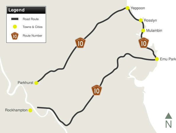
Yeppoon Road, Scenic Highway, hill Street, Emu Park Road, Lakes Creek Road & Bridge Street (Tourist Drive 10) |
Statistics:
- Length: 95 km
- Northern Terminus: Bruce Highway (A1) at Parkhurst
- Southern Terminus: Toft Street, Bridge Street, Linnett Street and Queen Elizabeth Drive (all unnumbered. Toft Street and Queen Elizabeth Drive form part of the former Bruce Highway alignment through Rockhampton's urban area) at Berserker
- Suburbs, Towns & Localities Along Route: Parkhurst, Limestone Creek, Ironpot, Mulara, Bondoola, Yeppoon, Rosslyn, Mulambin, Kinka Beach, Emu Park, Tungamull, Nerimbera, Lakes Creek, Koongal and Berserker
Route Numbering:
- Current:

- Road Authority Internal Classification: 194 (Emu Park to Berserker), 196 (Parkhurst to Yeppoon) and 197 (Yeppoon to Emu Park) 1
General Information:
Tourist Drive 10 (Capricorn Coast Tourist Drive) is a road linking Rockhampton with a number of towns popular with tourists, to the northeast of the city. A mix of divided and undivided road, the route services residential, commercial and rural properties.
History:
- May 2009: Commencement of widening of the Coorooman Creek Bridge. Work also commenced on widening and resurfacing a 3.7km section of Emu Park Road between Keppel Sands Road and Coowonga Road intersections. 2
- July 2009: Work started on widening 6.7km of the existing road, visibility improvements, and overlay works along Emu Park Road between Coowonga and Tanby Road. Also included was the installation of one overtaking lane at Palm Creek, and five intersection upgrades between Tungamull Creek and Tanby Road. 3
- 2010: Widening and rehabilitation of Emu Park Road between Tungamull and Tanby Road. The work included a bus pull over area and the widening of Coorooman Creek Bridge. 4
- February 2017: Completion of strengthening and widening of pavement including minor intersection upgrades between Goodsall Street and Thozet Road. Work also included Moores Creek Road / Musgrave Street intersection upgrade and Queen Elizabeth Drive / Lakes Creek Road intersection upgrade. 5
- June 2017: Completion of Emu Park Road / St Christopher's Chapel Road intersection upgrade. 5
- 27 July 2018: Scenic Hwy at Statue Bay reopens to traffic after major rehabilitation works to cliff faces, embankments and road, after damage caused by Tropical Cyclone Marcia. 6
- November 2020: Replacement of Frenchmans Creek Bridge. 5
- August 2021: Work commences on pavement rehabilitation works on a 3.7km section of Rockhampton-Yeppoon Road near Mt Baga National Park entrance. 7

 |
Reassurance Directional Sign:
Distance sign at Parkhurst, December 2002.
Image © Michael Greenslade
|
1 Queensland Government, Transport and Main Roads, Fitzroy Road Region map, Front, November 2011
2 Queensland Government, Transport and Main Roads, Main Roads Local Links, In and around Rockhampton, June 2009
3 Queensland Government, Transport and Main Roads, Main Roads Local Links, In and around Rockhampton, August 2009
4 Queensland Government, Transport and Main Roads, Main Roads Local Links, In and around Rockhampton, December 2010
5 Queensland Government, Transport and Main Roads, Projects, Rockhampton-Emu Park Road–Type 1 Road Train Access to Rockhampton Abattoirs
6 Queensland Government, Queensland Reconstruction Authority, News and Case Studies, Livingstone builds back better
7
Queensland Government, Transport and Main Roads, Projects, Rockhampton-Yeppoon Road, strengthen pavement
Last updated: 21-Oct-2021 0:18
This site © Paul Rands. All rights reserved. Some portions © (copyright) by their respective and credited owners. Permission must be obtained before using any images from this site. For details, please email by clicking here.


