|
|
|
|
|
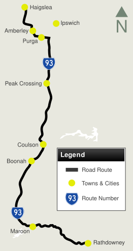
| Haigslea-Amberley Road, Ipswich-Rosewood Road, Cunningham Highway, Ipswich-Boonah Road & Boonah-Rathdowney Road (State Route 93) |
Statistics:
Route Numbering:


General Information:
State Route 93 is a mostly rural route, servicing residential, commercial and farm properties. It links the Cunningham Hwy (NH15) with Warrego Hwy (A2) and Mt Lindesay Hwy (NR13) and bypasses the town of Ipswich to the west.
Multiplexes along the route include:
History:

| Rathdowney to Haigslea | Haigslea to Rathdowney | |||
| Preview: | Description: | Preview: | Description: | |
 |
Advance Directional Sign: AD sign at Boonah on Boonah-Rathdowney Rd (SR93 / TD16), approaching Boonah Fassifern-Rd (SR90 / SR93) and Mt Carmel Rd, May 2005. SR93 turns right at this intersection and the SR90 duplex commences here as well. Image © Michael Greenslade |
 |
Reassurance Directional Sign: Distance sign at Walloon, March 2012. Image © Paul Rands |
|
 |
Advance Directional Sign: AD sign on Ipswich-Boonah Rd (SR93) approaching Roadvale Rd at Roadvale, May 2005. Image © Michael Greenslade |
 |
Bremer River: Haigslea-Amberley Rd (SR93) as it crosses Bremer River via Five Mile Bridge at Walloon, March 2012. Image © Paul Rands |
|
 |
Advance Directional Sign: AD sign at Amberley, approaching Hansens Rd, March 2012. Image © Paul Rands |
|||
 |
Hansens Road: Corner of Haigslea-Amberley Rd and Hansens Rd in Amberley, March 2012. Image © Paul Rands |
|||
 |
Advance Directional Sign: AD sign at Amberley approaching Ipswich-Rosewood Rd & Mt Elliott Mine Rd, March 2012. SR93 becomes Ipswich-Rosewood Rd at this junction. Image © Paul Rands |
|||
 |
Ipswich-Rosewood Road: ID signs at Amberley facing Haigslea-Amberley Rd (SR93) at the junction with Ipswich-Rosewood Rd & Mt Elliott Mine Rd, March 2012. SR93 becomes Ipswich-Rosewood Rd at this junction. The TD16 duplex also starts at this junction. Image © Paul Rands |
|||
 |
Rosewood Road: Ipswich-Rosewood Rd (SR93 / TD16) at the junction with Rosewood Rd in Amberley, March 2012. Image © Paul Rands |
|||
 |
Reassurance Directional Sign: Distance sign at Amberley, March 2012. Click here for a photo of this location from June 2009 by Michael Greenslade. Image © Paul Rands |
|||
 |
Advance Directional Sign: AD sign at Willowbank, approaching Heit St and Southern Amberley Rd, March 2012. Image © Paul Rands |
|||
 |
Advance Directional Sign: AD sign approaching Cunningham Hwy (NH15) at Willowbank, March 2012. Image © Paul Rands |
|||
 |
Cunningham Highway: Ipswich-Rosewood Rd (SR93 / TD16) at the Cunninham Hwy (NH15) junction at Willowbank, March 2012. SR93 and TD16 turn left at this junction, and pick up the NH15 triplex. Image © Paul Rands |
|||
 |
Entering Purga: Cunningham Hwy (NH15 / SR93 / TD16) as enters the town of Purga, March 2012. Image © Paul Rands |
|||
 |
Reassurance Directional Sign: Distance sign at Purga, March 2012. Image © Paul Rands |
|||
 |
Middle Road: Corner of Cunningham Hwy (NH15 / SR93 / TD16) at Purga, March 2012. TD16 turns right here, and Cunningham Hwy continues straight as NH15 / SR93. Image © Paul Rands |
|||
 |
Middle Road: Corner of Cunningham Hwy (NH15 / SR93 / TD16) at Purga, March 2012. TD16 turns right here, and Cunningham Hwy continues straight as NH15 / SR93. Image © Paul Rands |
|||
 |
Entering Yamanto: Cunningham Hwy (NH15 / SR93) as is enters Yamanto, March 2012. This is the beginning of motorway conditions. Image © Paul Rands |
|||
 |
Advance Directional Sign: AD sign at Yamanto, approaching the interchange with Centenary Hwy (A5), Ipswich-Boonah Rd (SR93) and Warwick Rd, March 2012. Image © Paul Rands |
|||
 |
Advance Directional Sign: AD sign at Yamanto approaching vehicle inspection site, March 2012. Image © Paul Rands |
|||
 |
Vehicle Inspection Site: Off ramp to vehicle inspection site at Yamanto, March 2012. Image © Paul Rands |
|||
 |
Advance Directional Sign: AD sign at Yamanto, approaching the interchange with Centenary Hwy (A5), Ipswich-Boonah Rd (SR93) and Warwick Rd, March 2012. Image © Paul Rands |
|||
 |
Supplemental Advance Directional Sign: Supplemental AD sign at Yamanto, approaching the interchange with Centenary Hwy (A5), Ipswich-Boonah Rd (SR93) and Warwick Rd, March 2012. Image © Paul Rands |
|||
 |
Centenary Highway, Ipswich-Boonah Road & Warwrick Road Interchange: Cunningham Hwy (NH15 / SR93) at the interchange with Centenary Hwy (A5), Ipswich-Boonah Rd (SR93) and Warwick Rd at Yamanto, March 2012. SR93 exits here and continues south. Image © Paul Rands |
|||
 |
Advance Directional Sign: AD sign Ipswich-Boonah Rd (SR93) at Coulson approaching Beaudesert-Boonah Rd (SR90), May 2005. The SR90 duplex starts at this location. Image © Michael Greenslade |
|||
 |
Reassurance Directional Sign: Distance sign at Boonah, May 2005. Image © Michael Greenslade |
|||
 |
Advance Directional Sign: AD sign at Dungandan approaching Bunburra Rd and Mt Alford Rd, May 2005. Image © Michael Greenslade |
|||
1 Queensland Government, Transport and Main Roads, 2016 State Road Network Map, South Coast District
2 Queensland Government, Transport and Main Roads Heritage Centre, Pennant; T-1169-0
3 Queensland Governement, Ministerial Media Statements, Upgrade for Five Mile Creek on Haigslea-Amberley Road, 30 Jun 2006
4 Queensland Governement, Ministerial Media Statements, Q150 Bridge names revealed for Scenic Rim, 26 Nov 2009
Last updated: 21-Oct-2021 19:49
This site © Paul Rands. All rights reserved. Some portions © (copyright) by their respective and credited owners. Permission must be obtained before using any images from this site. For details, please email by clicking here.