Road
Photos & Information: Queensland
 |
|
Mulligan highway & Peninsula Development Road (State Route 81) |
Statistics:
- Length: 752 km
- Northern
Terminus: Weipa town centre
- Southern
Terminus: Kennedy Hwy (NR1) at Mareeba
- Southern
Terminus: Formerly Cooktown Developmental Road
- Suburbs, Towns
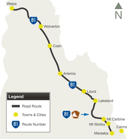
& Localities Along The Route: Mareeba, Biboohra, Mt Molloy, Mt Carbine, Lakeland, Laura, Kalinga, Artemis, Musgrave, Bamboo, Coen, Wolverton & Weipa
Route Numbering:
- Current:

- Former:

- Multiplexes:

- Road Authority
Internal Classification: 34A (Mareeba to Mt Molloy), 34B (Mt Molloy to Lakeland), 90B (Lakeland to Laura), 90C (Laura to Coen), 90D (Coen to Weipa) and 664 (Mareeba Town Centre) 1
General Information:
State Route 81 is a vital route in Queensland's cape territory.
The route passes though rural, residential and commercial areas, as well as mining interests and bushland. The route is mostly unsealed from 3.5 km west of Lakeland to Weipa Airport, a distance of around 550 km. The last sign mentioning State Route 81 is at Lakeland, a distance sign.
The route is named after bushman James Venture Mulligan.
Multiplexes along the route include:
- Great Tropical Drive, for 187 km, from Mareeba to Lakeland
History:
- 1950: The route of Mulligan Highway declared as a state controlled road. 2
- 1963: Mulligan Highway renamed Peninsula Developmental Road. 2
- 2000: Completion of bridge over Famechon Creek, on the Byerstown Range, 12 km south of Lakeland. The bridge is 35 m above the creek, and the second highest bridge in Queensland, after the Gateway Bridge. 3
- 2001: The Byerstown Range crossing was realigned and sealed at a cost of $17 million. 2
- January 2006: Completion of Mulligan Highway with the sealing of a 11.25 kilometre section between Sackley’s Hill and East Normanby River. 2
- 2007: Reinstatement of the name Mulligan Highway, between Mareeba and Cooktown. 2
- 2010: Famechon Creek bridge renamed Rollo Gallop Bridge. Rollo Gallop was an engineer known for his work for improving access to Cape York communities. He was District Engineer from 1946 until 1961 when he was appointed as Forward Planning Engineer for Far North Queensland Beef Roads until his retirement in 1965. During his career, Mr Gallop played a key role in the development of a number of roads in Far North Queensland including the Peninsula Developmental Road and the Cooktown Developmental Road in the Cook Shire. He was involved in the construction of the Gillies Highway and the Palmerston Highway was also Cook Shire Administrator during the 1960s. 3

 |
Distance Sign:
Reassurance directional sign at Mt Molloy, June 2012.
Image © Terry Siva
|
 |
Advance Directional Sign:
AD sign at Lakeland approaching Cooktown Development Rd (SR40), June 2012.
Image © Terry Siva
|
 |
Intersection Directional Sign:
ID sign at the junction with Cooktown Development Rd (SR40) at Lakeland, June 2012.
Image © Terry Siva
|
1 Transport and Main Roads, Queensland state-controlled roads and region maps, Far North Region: front and Far North Region: back
2 Queensland Government, Ministerial Media Statements, Highway commemorates far northern pioneer, 7 March 2009
3 Queensland Government, Ministerial Media Statements, Cape York bridge named after roads pioneer Rollo Gallop, 14 October 2010
Last updated: 17-Dec-2019 0:55
This
site ©
Paul Rands. All rights reserved. Some portions © (copyright) by their
respective and credited owners. Permission must be obtained before using
any images from this site. For details, please email by clicking
here.


