Road Photos & Information: Queensland
 |
|
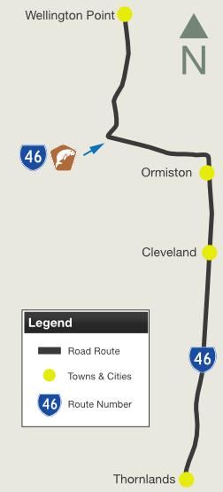
Main Road, Old Cleveland Road East, Sturgeon Street, Northern Arterial Road, Wellington Street and Panorama Drive (State Route 46) |
Statistics:
- Length: 11 km
- Northern Terminus: Birkdale Rd (SR43) and Main Rd (SR43) at Wellington Point
- Southern Terminus: Boundary Rd (SR21) at Thornlands
- Suburbs, Towns & Localities Along The Route: Wellington Point, Ormiston, Cleveland and Thornlands
Route Numbering:
- Current:

- Multiplexes:

General Information:
State Route 46 is a connector route on Brisbane's bayside. It's a mix of divided and undivided road, passing through mostly residential and commercial zones.
Multiplexes along the route include:
- Southern Moreton Bay Tourist Drive, for 6 km between Cleveland and Wellington Point

 |
Intersection Directional Sign:
ID sign near the the Shore St (SR22) roundabout at Ormiston, July 2011.
Image © Rob Tilley
|
 |
Distance Sign:
RD sign near Freeth St at Ormiston, July 2011.
Image © Rob Tilley
|
 |
Trailblazer:
SR46 trailblazer on Northern Arterial Rd at Ormiston, July 2011.
Image © Rob Tilley
|
 |
Advance Directional Sign:
AD sign on Northern Arterial Rd (SR46) approaching Sturgeon St (SR46), July 2011. SR46 turns left at this junction.
Image © Rob Tilley
|
 |
Intersection Directional Sign:
ID sign at the Sturgeon St and Northern Arterial Rd roundabout at Ormiston, July 2011.
Image © Rob Tilley
|
 |
Black Advance Directional Sign:
Faded black AD sign at Alexandra Hills on Old Cleveland Rd East (SR46) approaching Allenby Rd, the SR55 section of Old Cleveland Rd East and Main Rd (SR46), July 2011. SR46 turns right at this roundabout.
Image © Rob Tilley
|
Last updated: 17-Dec-2019 0:55
This site ©
Paul Rands. All rights reserved. Some portions © (copyright) by their respective and credited owners. Permission must be obtained before using any images from this site. For details, please email by clicking here.

