Road
Photos & Information: Queensland
 |
|
East Evelyn Road (State Route 24) |
Statistics:
- Length: 11 km
- Eastern Terminus: Palmerston Hwy (SR25) at Millaa Millaaa
- Western Terminus: Kennedy Hwy (NR1) at East Evelyn
- Suburbs, Towns & Localities Along Route: Millaa Millaa and East Evelyn
Route Numbering:
- Current:

- Road Authority Internal Classification: 6404
1
General Information:
East Evelyn Road is a short State Route located in the Far North Queensland hinterland. A rural undivided route, it links Palmerston Hwy (SR25) with Kennedy Hwy (NR1).
East Evelyn road leads to Queensland's Highest Main Road passing the Millaa Millaa Lookout. 2
History:
- November 1946: Grading of the existing pavement to profile, the making-up of flanks, arid re-sheeting with fine crushed rock of the East Evelyn Road at an estimated cost of £2491. 3
- October 2010: Work commenced on East Evelyn Road to increase visibility for motorists approaching the intersection with Millaa Millaa-Malanda Road. Power was installed at the intersection to upgrade the flashing warning signs and lighting to make it safer at night and in wet and foggy conditions. 4


|
Reassurance Directional Sign:
Distance sign at Millaa Millaa, August 2014. Note the missing SR24 shield.
Image © Ed Huang
|

|
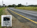
Edge Line Trial:
Special edge line trial at Millaa Millaa, August 2014.
Image © Ed Huang
|
1
Department of Transport and Main Roads, Queensland State Controlled
Roads and Regions Maps, Far North Region, June 2011
2 millaamillaa.com, Activities
3 Cairns Post, Friday 1 November 1946
4 Department of the Premier and Cabinet, Media Statements, Safety Upgrade for East Evelyn Intersection
Last updated: 18:50:27 15/3/2015.
This site ©
Paul
Rands. All rights reserved. Some portions © (copyright) by their
respective and credited owners. Permission must be obtained before
using any images from this site. For details, please email by clicking here.
