|
|
|
|
|
 |
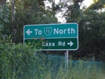
| Advance directional sign on Messines Ridge Rd at Holland Park West approaching South East Fwy interchange. March 2006. Image © Paul Rands |
In 1964 Main Roads and Brisbane City Council jointly commissioned an American consulting engineering firm, Wilbur Smith and Associates, to undertake a transport planning study for Brisbane. The Wilbur Smith "Brisbane Transportation Study" was published in 1965 and made recommendations covering sixteen years to 1981. 1
The Wilbur Smith plan proposed a "ring-radial" freeway system for Brisbane. Implementing the recommended changes was a major task as it involved significant land acquisitions and a large amount of freeway planning and design. 1
One of the more significant achievements was the completion of the South-East Freeway / Captain Cook Bridge / Riverside Expressway. The Wilbur Smith Plan had a proposed implementation period of sixteen years. However most of that time had been taken up building the South-East Freeway and the Riverside Expressway. 1
Whereas works on other elements of Wilbur Smith's ring-radial road plan had ceased, some other important road projects had been undertaken in the latter half of the 1970's. The Houghton Highway across Bramble Bay was built and major improvements were made to the Bruce Highway leading out of Brisbane to the north. 1
Below are the various roads that this site has photos of. The routes are sorted by their route number.
| Route Number: | Description: | Preview: |
 |
F3 (Brisbane CBD to Springwood): South East Freeway & Riverside Expressway |
 |
1 Main Roads Queensland, History of Brisbane's Major Arterial Roads, September 2011
Last updated: 14-Feb-2019 21:46
This site © Paul Rands. All rights reserved. Some portions © (copyright) by their respective and credited owners. Permission must be obtained before using any images from this site. For details, please email by clicking here.