|
|
|
|
|
 |
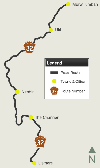
Alma Street, Wollumbin Street, Riverview Street, Kyogle Road, Blue Knob Road, Nimbin Road, Koonorigan Road, Terania Street, The Channon Road, Dunoon Road, Tweed Street, Miles Street & Woodlark Street (Tourist Drive 32) |
Statistics:
Route Numbering:


General Information:
Tourist Drive 32 is a rural route servicing several small towns and passes through farmland, and forested areas, including Mt Warning National Park, which features the amazing Mt Warning volcanic rock formation.
The route passes through the town of Nimbim, famous for alternate lifestyles and the people they attract.
Multiplexes along the route include:
History:

| Lismore to Murwillumbah | Murwillumbah to Lismore | |||
| Preview: | Description: | Preview: | Description: | |
 |
Cooloon Street: ID sign at the corner of Kyogle Rd (TD32) and Cooloon St at Kunghur, July 2018. Image © Rob Tilley |
 |
Advance Directional Sign: AD sign on Wollumbin St (TD32 / TD42) approaching Commercial Rd and Main St in Murwillumbah, July 2018. Image © Rob Tilley |
|
 |
Doon Doon Road: ID sign at the corner of Kyogle Rd (TD32) and Doon Doon Rd at Kunghur, July 2018. Image © Rob Tilley |
 |
Reassurance Directional Sign: Distance sign on Wollumbin St (TD32 / TD42) in Murwillumbah, July 2018. Image © Rob Tilley |
|
 |
Byrrill Creek Road: Corner of Kyogle Rd (TD32) and Byrrill Ck Rd at Byrrill Creek, July 2018. Image © Rob Tilley |
 |
Advance Directional
Sign: AD sign on Wollumbin St in Murwillumbah, February 2009. Image © Rob Tilley |
|
 |
Entering Uki: Kyogle Rd (TD32) as it enters the town of Uki, July 2018. Image © Rob Tilley |
 |
Brisbane Street: Corner of Wollumbin St (TD32) and Brisbane St (TD34 / TD42) in Murwillumbah, July 2018. The TD42 duplex ends here. Image © Rob Tilley |
|
 |
Advance Directional Sign: AD sign at Uki approaching Mt Warning Rd, July 2018. Image © Rob Tilley |
 |
Reassurance Directional Sign: Distance sign on Wollumbin St (TD32) in Murwillumbah, July 2018. Image © Rob Tilley |
|
 |
Mount Warning Road: ID sign assembly at the junction with Mt Warning Rd at Uki, July 2018. Image © Rob Tilley |
 |
Distance Sign: RD sign on Wollumbin St in Murwillumbah, February 2009. Image © Rob Tilley |
|
 |
Intersection Directional Sign: ID sign facing Mt Warning Rd at Uki, July 2018. Image © Rob Tilley |
 |
Advance Directional
Sign: AD sign on Wollumbin St (TD32) approaching Riverview St (TD32) in Murwillumbah, July 2018. Click here for a photo of this location by Rob Tilley from February 2009. Image © Rob Tilley |
|
 |
Murwillumbah: Kyogle Rd (TD32) as it enters the town of Murwillumbah, July 2018. Image © Rob Tilley |
 |
Intersecton
Directional Sign: ID sign on Wollumbin St (TD32) at the junction with Riverview St (TD32) in Murwillumbah, July 2018. Click here for a photo of this location by Rob Tilley from February 2009. Image © Rob Tilley |
|
 |
Intersection Directional Sign: ID sign at the junction with Wollumbin St in Murwillumah, July 2018. TD32 turns right at this location. Image © Rob Tilley |
|||
 |
Advance Directional Sign: AD sign approaching the junction with Brisbane St (TD34 / TD42) in Murwillumbah, February 2009. The TD42 duplex commences at this intersection. Image © Rob Tilley |
|||
 |
Advance Directional Sign: AD sign at Murwillumbah approaching Tweed Valley Way (TD40), July 2018. Image © Rob Tilley |
|||
 |
End Tourist Drive 32 & 42: Sign indicating end of TD32 and TD42 at the junction with Tweed Valley Way (TD40) at Murwillumbah, July 2018. Image © Rob Tilley |
|||
 |
Tweed Valley Way: AD style sign acting as ID sign at the junction with Tweed Valley Way (TD40) at Murwillumbah, July 2018. Image © Rob Tilley |
|||
1 Roads and Traffic Authority, Schedule of Classified Roads and State & Regional Roads, January 2011
2 Tweed Shire Council, Media Release, Mayor of Tweed officially opens Tom Grant Bridge at Mount Burrell, 8 December 2011
Last updated: 11-Jul-2019 10:21
This site © Paul Rands. All rights reserved. Some portions © (copyright) by their respective and credited owners. Permission must be obtained before using any images from this site. For details, please email by clicking here.