Road Photos & Information: New South Wales
 |
|
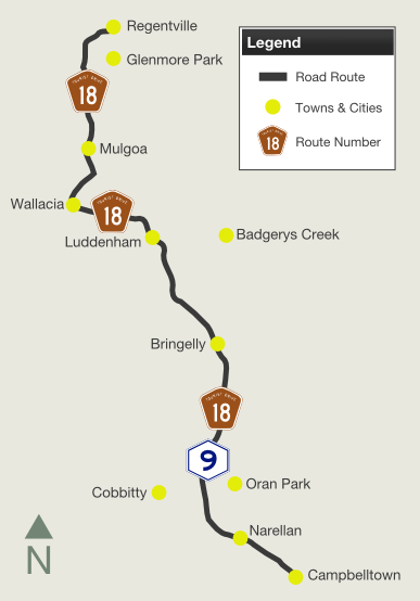
Mulgoa Road, Park Road, The Northern Road
& Narellan Road (Tourist Drive 18) (Decommissioned) |
Statistics:
- Length: 45 km
- Northern Terminus: Western Freeway (Metroad 4) and Mulgoa Road, Regentville
- Southern Terminus: Hume Highway (Metroad 5 / NH31) and Narellan Road (Metroad 9) at Mount Annan
- Suburbs, Towns & Localities along route: Regentville, Glenmore Park, Mulgoa, Wallacia, Luddenham, Badgerys Creek, Bringelly, Oran Park, Cobbity, Narellan, & Mount Annan.
Route Numbering:
- Former:


- Road Authority Internal Classification: MR154 (Northern Road) and MR178 (Narellan Road) 1
General Information:
TD18 takes in part of the former SR73 alignment from Jamisontown (near Penrith) to Wallacia before travelling along Metroad 9 (former SR69) to its terminus with the Hume Highway / South Western Motorway near Campbelltown. The route passes through the greenbelt and farm areas of the Sydney fringe.
It consists entirely of single carriageway roadway with some overtaking lanes south of Luddenham.
History:
- 1990: Construction of roundabout at the Mulgoa Rd and Glenmore Pkwy intersection. The housing estate of Glenmore Park was officially opened by Premier Nick Greiner. 2
- 1998: SR73 Decomissioned. SR69 between Windsor and Campbelltown replaced with Metroad 9.
- 26 October 2007: TD18 / Metroad 9, shifted to new alignment for Northern Road at Narellan. Click here for more details 1

 |
Advance Directional Sign:
Travelling southwest at Jamisontown on Mulgoa Road as you approaching the interchange with the Western Mwy (Metroad 4) and the continuation of Mulgoa Road as Tourist Drive 18. SR73 is coverplated between the TD18 shield and Wallacia legend on the sign. October 2005.
Image © Paul Rands |
 |
Start Tourist Drive 18:
Looking southwest as you approach the tourist orientated distance sign near School House Road and Spencer Street in Regentville.
October 2005.
Image © Paul Rands |
 |
RD Sign:
Reassurance directional sign as you approach the intersection with School House Road and Spencer Street at Regentville. October 2005.
Image © Paul Rands |
 |
Advance Directional Sign:
AD sign as you travel southwest on Mulgoa Road, as you approach the Glenmore Parkway, Glenmore Park, October 2005.
Image © Paul Rands |
1 Roads & Traffic Authority
2 Penrith City Council
Last updated: 17-Dec-2019 0:55
This site ©
Paul Rands. All rights reserved. Some portions © (copyright) by their respective and credited owners. Permission must be obtained before using any images from this site. For details, please email by clicking here.


