Road
Photos & Information: New South Wales
 |
|
City Road, King Street, Enmore Road, Stanmore
Road, New Canterbury Road, Canterbury Road, Milperra Road, Newbridge
Road, Terminus Street & Macquarie Street (State Route 54) (Decommissioned) |
Statistics:
- Length: 28
km
- Eastern Terminus: Parramatta Road and Broadway (SR31) at Chippendale
- Western Terminus: Hume Highway and Hoxton Park Road at Liverpool
- Suburbs, Towns
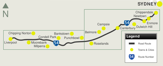
& Localities along route: Liverpool, Moorebank, Chipping
Norton, Milperra, Bankstown Airport, Condell Park, Revesby, Bankstown,
Punchbowl, Wiley Park, Roselands, Lakemba, Belmore, Kingsgrove,
Campsie, Canterbury, Hurlstone Park, Dulwich Hill, Lewisham, Petersham,
Stanmore, Enmore, Newtown, Camperdown, Darlington and Chippendale.
Route Numbering:
- Former:


- Road Authority Internal Classification: State Highway No. 1 (City Road and King Street), Main
Road No. 167 (Enmore Road, Stanmore Road, New Canterbury Road,
Canterbury Road, Milperra Road & Newbridge Road) & Main Road
578 (Terminus Street & Macquarie Street). 1
- Decommissioned: 2013
General Information:
The route is made up of generally 4 to 6 lane wide
pavement, the latter covering the Milperra Road and Newbridge Road
section of the route. SR54 passes through a vast range of areas of
Sydney, including residential, industrial and commercial.
History:
- 1831: Introduction of punt over Cooks River in
Canterbury by Cornelius Prout. 1
- 1841: Construction of Prouts Bridge over Cooks
River in Canterbury by convict labour. 1
- 1927: Ruling put in place so that any new
buildings along Princes Highway (King Street) in Newtown would be built
further back from the road, so a wider alignment could be constructed. 1
- 1928: Removal of kerbside petrol pumps along
Canterbury Road in the Canterbury Council area. 1
- 1947: Replacement of Prouts Bridge over Cooks
River in canterbury begins. 1
- 1951: Completion of current Prouts Bridge at
Canterbury. 1
- 2006: Construction commenced on pedestrian
bridge (near Church Street) over Canterbury Road, Canterbury. 1
- April 2006: Installation of new traffic signals
at Canterbury Road and Duke Street, Campsie. 1
To view photos of the route, click inside the green boxes below:

1 Roads & Traffic Authority
Last updated: 14-Aug-2020 18:50
This site ©
Paul Rands. All rights reserved. Some portions © (copyright) by their respective and credited owners. Permission must be obtained before using any images from this site. For details, please email by clicking here.

