Road
Photos & Information: New South Wales
 |
|
Old Northern Road, Wisemans Ferry Road and Peats Ridge Road (State Route 36) (Decommissioned) |
Statistics:
- Length: 119 km
- Northern
Terminus: Sydney-Newcastle Freeway (NH1) at Somersby
- Southern
Terminus: Windsor Road (former SR40), Old Northern Road and Seven Hills Road at Baulkham Hills
- Suburbs, Towns
& Localities Along The Route: Baulkham Hills, Castle Hill, Glenhaven, Dural, Middle Dural, Glenorie, Forest Glen, Canoelands, Maroota, Wisemans Ferry, Gunderman, Spencer, Lower Mangrove, Greengrove, Mangrove Creek, Mangrove Mountain, Central Mangrove, Peats Ridge and Somersby
Route Numbering:
- Current:
None
- Former:


- Road Authority
Internal Classification: MR160 (Baulkham Hills to Maroota), MR181 (Maroota to Wisemans Ferry), MR225 (Wisemans Ferry to Peats Ridge) and MR455 (Peats Ridge to Somersby) 1
General Information:
State Route 36 was formed via a network of roads in Sydney's northwest and rural Central Coast of New South Wales. Within Sydney, the route varies from multil-laned to single lane in each direction design. On the Central Coast, the road is undivided single carriageway.
The road passes through residential, commercial, rural and bushland areas, and is serviced by a vehicular ferry, which crosses the Hawkesbury River at Wisemans Ferry. The ferry is one of only ten RTA controlled vehicular ferry services are still in operation in the state. The ferry road deck is marked for three lanes of traffic. 2
The Old Northern Road section of the route is formed by the convict built The Great North Road between Castle Hill and Wisemans Ferry. 3 The Great North Road, passing through Wisemans Ferry, was the main route north to Newcastle until the middle of the twentieth century. 2
History:
- 1825 to 1834: The Great North Road was surveyed and constructed. Running from Windsor Road in Baulkham Hills to Wisemans Ferry, then to Maitland and Singleton. The road reached the small settlement of Wisemans Ferry the late 1820s. 2
- 1827: The first ever Wisemans Ferry service was started by Solomon Wiseman. 2
- 1829: The current Wisemans Ferry crossing was setup and the location is still in use today. General Sir Thomas Mitchell oversaw the relocation of the northern ascent of the Great North Road to its present alignment, which saw the relocation of the ferry to its present location. 2
- 1832: The Wisemans ferry service was purchased by the Crown for an amount of £267. 2
- 1927: Hand winch operation of the punt at Wisemans Ferry upgraded to a motorised winch. 2
- April 1930: A new punt was installed and the approaches on either side of the River were upgraded with sandstone pavers. Signage and barrier gates were also installed. 2
- 1934: Wisemans Ferry Road through Spencer opens. 4
- 1978: Ferry access ramps were upgraded from pavers to concrete. 2
- 1996: The existing hydraulically operated boom gates with aluminium arms and steel pedestals were installed on the ferry approaches. 2
- 1997: Flat skid bars on both ferry approaches were replaced as the existing ones were badly worn and missing in places. 2
- 2008: Work commences on replacement of timber bridges along the route at Popran, Bedlam Creek, Ironbark Creek, Scotchmans Creek, Spencer, Cohens Creek, Gunderman Creek and Mill Creek. 5
- 2011: Beautification works along the Old Northern Road between Showground Road and Crane Road at Castle Hill were completed. 6

| |
| |
 |
Intersection Directional Sign:
ID sign at Central Mangrove at the George Downes Dr (TD33) junction, December 2008.
Image © Paul Rands |
|
 |
Intersection Directional Sign:
AD sign acting as an ID sign at St Albans at the junction with Settlers Rd. August 2009. Note the remnant and incorrect route number shield.
Image © Richard Wardle
|
 |
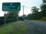
Distance Sign:
RD sign at Central Mangrove, December 2008.
Image © Paul Rands |
|
 |
Distance Sign:
RD sign at Central Mangrove, December 2008.
Image © Paul Rands
|
| |
|
|
 |
Intersection Directional Sign:
ID sign at Central Mangrove at the George Downes Dr (TD33) junction, December 2008.
Image © Paul Rands
|
1 Roads & Traffic Authority, Schedule of Classified Roads and State & Regional Roads, January 2011
2 Roads & Traffic Authority, Heritage and Conservation Register, Cable Ferry Crossing, Wisemans Ferry
3 Hornsby Shire Council, Library, Street & Place Names Index, Old Northern Road
4 Roads & Traffic Authority, Bridging The Hawkesbury River, Hornsby to Gosford Heritage Drive brochure
5 Roads & Traffic Authority, Projects, Timber Bridge Patnership, December 2008
6 Roads & Traffic Authority, Projects, Sydney Region, Northern Sydney, Castle Hill main street project
Last updated: 17-Dec-2019 0:55
This site ©
Paul Rands. All rights reserved. Some portions © (copyright) by their respective and credited owners. Permission must be obtained before using any images from this site. For details, please email by clicking here.


