Road
Photos & Information: New South Wales
 |
|
Kamilaroi Highway (National Route 37) (Decommissioned) |
Statistics:
- Length: 602 km
- Eastern
Terminus: New England Hwy (NH15) at Willow Tree
- Western
Terminus: Mitchell Hwy (NR71) at Bourke
- Suburbs, Towns
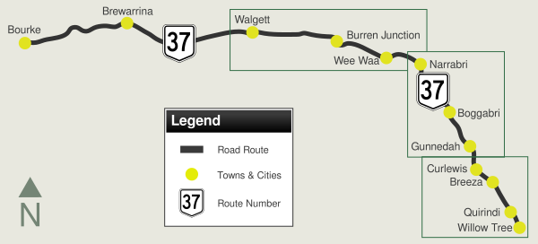
& Localities Along The Route: Willow Tree, Quirindi, Curlewis, Gunnedah, Boggabri, Narrabri, Wee Waa, Burren Junction, Cryon, Walgett, Brewarrina and Bourke
Route Numbering:
- Former:

- Multiplexes:


- Road Authority
Internal Classification: HW29 1
- Decommissioned: 2013
General Information:
The highway is named after the Kamilaroi Aboriginal people of north western NSW. 2 The route connects the Hunter Valley with the far northwest outback of New South Wales.
The route consists of mostly single carriageway undivided roadway, passing through nature reserves, farmland, commercial and residential areas.
Multiplexes along the route include:
- National Highway 39, for 5 km at Narrabri
- National Route 34, for 2 km at Gunnedah
- National Route 55, for 4 km at Walgett
- Tourist Drive 25, for 14 km between Quirindi and Willow Tree
History:
- 7 December 1888: Official opening of the wrought iron Brewarrina Bridge over the Barwon River. The main span is 16.8m in length and there are four approach spans on each side, all approximately 9m in length. The overall length is 91m and the Bridge has a single lane 4.5m wide between kerbs. The roadway is carried on cross girders covered with timber deck. It is the second oldest lift bridge in New South Wales. 2
- 13 February 1999: The Kamilaroi Highway was officially proclaimed by the Minister for Roads. 3
- December 1999: Final stage of Kamilaroi Highway upgrade completed to provide a continuous, dependable all weather road to the north west portion of New South Wales. 3
- 2002: Widening of the highway, 24km of the Kamilaroi Highway west of Narrabri. 4

1 Roads & Traffic Authority, Schedule of Classified Roads and State & Regional Roads, January 2011
2 Roads & Traffic Authority, Heritage and Conservation Register, Brewarrina Bridge over Barwon River
3 Roads & Traffic Authority, Annual Report 2000, November 2000, ISSN 1037-3276
4 Roads & Traffic Authority, Annual Report 2002
Last updated: 11-Sep-2020 17:45
This site ©
Paul Rands. All rights reserved. Some portions © (copyright) by their respective and credited owners. Permission must be obtained before using any images from this site. For details, please email by clicking here.


