Road Photos & Information: New South Wales
Route Number Snowy Mountains Highway (National Route 18) - Nimmitabel to Bega: Former Alignment (Decommissioned)

Statistics:

Route Numbering:

General Information:

Snowy Mountains Highway is a route that connects the Southern Tablelands of New South Wales with the far south coast via the Great Dividing Range and Snowy Mountains. It's mostly a 2-lane undivided rural highway, passing through farmland, residential and commercial regions. Large tracts of the route pass through national parks and traverse very hilly and steep terrain.

The route links the Princes Hwy (NR1), Monaro Hwy (NR23) and Hume Hwy (NH31). The highest town along the highway is Kiandra, at a height of 1400 metres. 2

History:

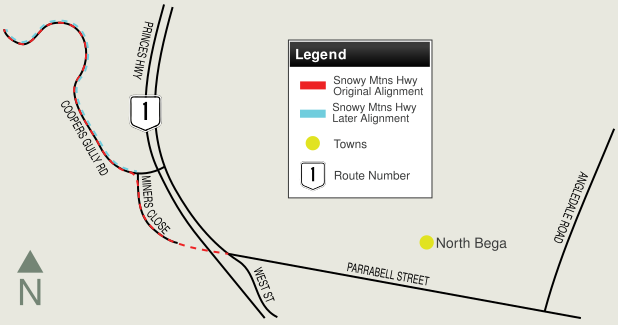
According to Sam Laybut (OzRoads), there were several alignment arrangements at the Bega end of the Snowy Mountains Highway before the route was put on it current alignment. The routings were as follows:

  1. Princes Highway was via what is now Angledale Road, so Snowy Mountains Highway came down what is now Coopers Gully Road, along Miners Close into North Bega, meeting Princes Highway outside the cheese factory at the northern end of the old bridge.
  2. Princes Highway was deviated via the current route but went via Miners Close into North Bega. This meant Snowy Mountains Highway was cut back to the Coopers Gully Road / Miners Close intersection.

See the map below for further clarification:
Nimmitabel to Bega   Bega to Nimmitabel
Preview: Description:   Preview: Description:
Old Alignment at Bemboka:
Old highway alignment near the base of Brown Mountain at Bemboka, January 2010. Apparently this segment was bypassed as part of a deviation near Nunnock River in the 1980s. 5

Image © Paul Rands

  Miners Close:
Miners Close in North Bega, which was once both a former alignment of Snowy Mountains Highway and also Princes Highway, January 2010. Note the old yellow road markings

Image © Paul Rands

Old Alignment in Bemboka Town Centre:
Old highway alignment outside the catholic church on what is now known as Loftus St, January 2010.

Image © Paul Rands

  Coopers Gully Road:
Coopers Gully Rd in Nth Bega, the former alignment of Snowy Mtns Hwy, January 2010.

Image © Paul Rands

Timber Bridge:
Timber bridge over Hanscomb Creek at Coopers Gully, February 2010.

Image © Paul Rands

  Coopers Gully Road:
Coopers Gully Rd in Nth Bega, the former alignment of Snowy Mtns Hwy, January 2010.

Image © Paul Rands

Miners Close:
Miners Close in North Bega, which was once both a former alignment of Snowy Mountains Highway and also Princes Highway, January 2010.

Image © Paul Rands

  Older Alignment:
Old road alignment now on someone's property, North Bega, January 2010.

Image © Paul Rands

Miners Close:
Miners Close in North Bega, which was once both a former alignment of Snowy Mountains Highway and also Princes Highway, January 2010.

Image © Paul Rands

  Coopers Gully Road:
Coopers Gully Rd in Nth Bega, the former alignment of Snowy Mtns Hwy, January 2010.

Image © Paul Rands

      Mile Post:
Old mile post at Coopers Gully, February 2010. "B" is short for Bega (3 miles) and "N" is short for Nimmitabel (45 miles)

Image © Paul Rands

      Coopers Gully Road:
Coopers Gully Rd in Coopers Gully, the former alignment of Snowy Mtns Hwy, January 2010.

Image © Paul Rands

      Old Narrow Bridge Sign:
Old faded narrow bridge sign on timber post approaching Hanscomb Creek at Coopers Gully, February 2010.

Image © Paul Rands

      Timber Bridge:
Timber bridge over Hanscomb Creek at Coopers Gully, February 2010.

Image © Paul Rands

      Old Narrow Bridge Sign:
Old faded narrow bridge sign on timber post approaching Johnson Creek at Coopers Gully, February 2010.

Image © Paul Rands

      Approaching Johnson Creek:
Timber bridge over Johnson Creek at Coopers Gully, February 2010.

Image © Paul Rands

      Timber Bridge:
Timber bridge over Johnson Creek at Coopers Gully, February 2010.

Image © Paul Rands

      Coopers Gully Road:
Coopers Gully Rd in Coopers Gully, the former alignment of Snowy Mtns Hwy, January 2010.

Image © Paul Rands

      Old Alignment in Bemboka Town Centre:
Old highway alignment outside the catholic church on what is now known as Loftus St, January 2010.

Image © Paul Rands

1 Roads and Traffic Authority, Schedule of Classified Roads (and unclassified Regional Roads), 20 February 2009
2 Department of Main Roads, Main Roads of New South Wales, undated brochure
3 State Library of NSW, Manuscripts, Oral History & Pictures, Bridge construction over Bemboka River at Morans Crossing
4 Department of Main Roads, The Roadmakers, A History of Main Roads in New South Wales, ISBN0 7240 0439 4, page 218
5 Sam Laybutt (Ozroads)

Last updated: 18-Dec-2019 12:56

This site © Paul Rands. All rights reserved. Some portions © (copyright) by their respective and credited owners. Permission must be obtained before using any images from this site. For details, please email by clicking here.