 |
New South Wales / Queensland Border:
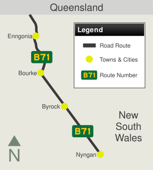
Crossing from Queensland into New South Wales at Barringun, November 2016. The Mitchell Hwy changes at this location from A71 in Queensland to B71 in New South Wales.
Image © Paul Rands |
 |
Reassurance Directional Sign:
Tourism-based distance sign at Barringun, November 2016.
Image © Paul Rands |
 |
Entering Barringun:
Mitchell Hwy (B71) as it enters the town of Barringun, November 2016.
Image © Paul Rands |
 |
Entering Barringun:
Mitchell Hwy (B71) as it passes through the town of Barringun, November 2016.
Image © Paul Rands |
 |
Services Sign:
Services sign leaving Barringun town centre, November 2016.
Image © Paul Rands |
 |
Kidman Way Sign:
Southbound sign on Mitchell Hwy (B71) at Barringun showing the towns along the Kidman Way, which starts in Bourke, November 2016.
Image © Paul Rands |
 |
Entering Enngonia:
Mitchell Hwy (B71) as it enters the town of Engonnia, November 2016.
Image © Paul Rands |
 |
McCabe Street:
Corner of Mitchell Hwy (B71) and McCabe St, Engonnia, November 2016.
Image © Paul Rands |
 |
Shearer Street:
Corner of Mitchell Hwy (B71) and Shearer St, Engonnia, November 2016.
Image © Paul Rands |
 |
Lower Lila Road:
Corner of Mitchell Hwy (B71) and Lower Lila Rd at North Bourke, November 2016.
Image © Paul Rands |
 |
Twin Rivers Road:
Corner of Mitchell Hwy (B71) and Twin Rivers Rd at North Bourke, November 2016.
Image © Paul Rands |
 |
Bundy Road:
Corner of Mitchell Hwy (B71) and Bundy Rd at North Bourke, November 2016.
Image © Paul Rands |
 |
Advance Directional Sign:
AD sign at North Bourke approaching Hungerford Rd, November 2016. B71 turns left at this intersection.
Image © Paul Rands |
 |
Darling River:
Mitchell Hwy (B71) as it crosses Darling River via Gateway Bridge at North Bourke, November 2016.
Image © Paul Rands |
 |
Polygonum Swamp:
Mitchell Hwy (B71) as it crosses Polygonum Swamp at Bourke, November 2016.
Image © Paul Rands |
 |
Polygonum Swamp:
Mitchell Hwy (B71) as it crosses the Billabong of Polygonum Swamp at Bourke, November 2016.
Image © Paul Rands |
 |
Advance Directional Sign:
AD sign at Bourke approaching Mitchell St and Richard St, November 2016.
Image © Paul Rands |
 |
Mitchell Street & Richard Street:
Intersection directional sign on the junction with Mitchell St and Richard St in Bourke, November 2016. B71 turns left at this location.
Image © Paul Rands |
 |
Advance Directional Sign:
AD sign at Bourke approaching Kidman Way (B87) and Anson St, November 2016.
Image © Paul Rands |
 |
Kidman Way & Anson Street:
Intersection directional sign on the junction with Kidman Way (B87) and Anson St in Bourke, November 2016. B71 turns left at this location.
Image © Paul Rands |
 |
Reassurance Directional Sign:
Distance sign leaving Bourke, November 2016.
Image © Paul Rands |
 |
Entering Byrock:
Mitchell Hwy (B71) as it enters the town of Byrock, November 2016.
Image © Paul Rands |
 |
Intersection Directional Sign:
Non-standard fingerboards at the corner of Gongolgon St and Cobar St in Byrock, November 2016.
Image © Paul Rands |
 |
Cooneybar Road:
Corner of Mitchell Hwy (B71) and Cooneybar Rd at Coolabah, November 2016.
Image © Paul Rands |
 |
Advance Directional Sign:
AD sign approaching Arthur Hall VC Way at Coolabah, November 2016.
Image © Paul Rands |
 |
Arthur Hall VC Way:
Corner of Mitchell Hwy (B71) and Arthur Hall VC Way at Coolabah, November 2016.
Image © Paul Rands |
 |
Reassurance Directional Sign:
Distance sign at Coolabah, November 2016.
Image © Paul Rands
|
 |
Entering Girilambone:
Mitchell Hwy (B71) as it enters the town of Girilambone, November 2016.
Image © Paul Rands |
 |
Booramugga Road:
Corner of Mitchell Hwy (B71) and Booramugga Rd at Girilambone, November 2016.
Image © Paul Rands
|
 |
Advance Directional Sign:
AD sign at Nyngan approaching Mitchell Hwy (A32) and Barrier Hwy (A32), November 2016.
Image © Paul Rands
|
 |
Mitchell Highway & Barrier Highway:
Southern terminus of B71: Mitchell Hwy (A32) and Barrier Hwy (A32) at Nyngan, November 2016.
Image © Paul Rands
|

