Road Photos & Information: Australian Capital Territory
Athllon Drive
Statistics:
- Length: 11 km
- Northern Terminus: Hindmarsh Drive & Callam Street, Phillip
- Southern Terminus: Isabella Drive & Drakeford Drive, Greenway
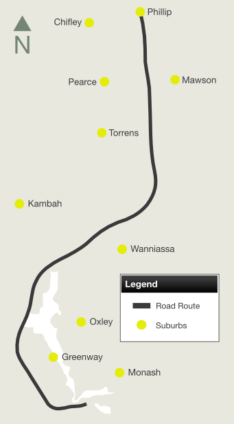
- Suburbs, Towns & Localities Along Route: Phillip, Mawson, Chifley, Pearce, Torrens, Kambah, Wanniassa, Oxley and Greenway
Route Numbering:
General Information:
Athllon Drive is mostly a divided arterial road linking the Woden Town Centre (Phillip) with the Tuggeranong Town Centre (Greenway). The route services residential, commercial and light industrial areas and passes west of the man-made Lake Tuggeranong.
History:
- 27 March 1979: Athllon Drive between Melrose Drive and Beasley Street opened to traffic. 1
- December 1981: Work started on a $110 000 traffic roundabout to replace the T-junction where Athllon Drive meets Sulwood Drive at Wanniassa. 2
- 13 October 1988: The main northern access to Tuggeranong Town Centre, Athllon Drive, was opened to traffic. The road traverses the dam forming Lake Tuggeranong. 3
- 1991: Road widening, improved intersections, special bus lanes and better pedestrian access was carried out on Athllon Drive between Hindmarsh Drive, Phillip, and Sulwood Drive, Wanniassa. 4
- July 1995: Bus lanes along Athllon Drive converted to transit lanes. 5
- 25 June 2015: Part-time traffic signals installed on the eastern approach to the Isabella Drive / Drakeford Drive / Athllon Drive roundabout switched on. 6

| |
| |
 |
Black Advance Directional Sign:
Black AD sign on Athllon Dr at Kambah approaching Fincham Cr, August 2013.
Image © Paul Rands |
|
 |
Advance Directional Sign:
AD sign at Wanniassa approaching Drakeford Dr, August 2013.
Image © Paul Rands |
 |
Beasley Street:
Beasley St Torrens at the junction with Athllon Dr, April 2015.
Image © Paul Rands
|
|
 |
Beasley Street:
Beasley St Farrer at the junction with Athllon Dr, April 2015.
Image © Paul Rands |
 |
Advance Directional Sign:
AD sign at Pearce on Beasley St approaching Athllon Dr, April 2015.
Image © Paul Rands
|
|
|
|
1 Canberra Times, New section of Athllon Drive opens tomorrow, Page 7, 26 Mar 1979
2 Canberra Times, Athllon Drive, Page 3, 9 December 1981
3 Canberra Times, Athllon Drive open, lake nearly full, Page 4, 14 October 1988
4 Canberra Times, Athllon Upgrading, Page 2, 2 May 1991
5 Canberra Times, From bus only, now it's transit, Page 2, 5 July 1995
6 ACT Government, Media Releases, Part-time signals help improve traffic flow for Tuggeranong Valley, 26 June 2015
Last updated: 19-Feb-2017 13:48
This site © Paul Rands. All rights reserved. Some portions © (copyright) by their respective and credited owners. Permission must be obtained before using any images from this site. For details, please email by clicking here.
